BYRON'S GAMES

  • Start Here
  • Meet Byron
  • Get the Game
  • Video Series
  • Blog
  • Explore More
  • Store
  • Get the App!
  • Join our Community
  • Start Here
  • Meet Byron
  • Get the Game
  • Video Series
  • Blog
  • Explore More
  • Store
  • Get the App!
  • Join our Community

Where In The World Wednesday: Isle of Skye, Scotland

12/4/2019

1 Comment

 
Picture
The Isle of Skye, commonly known as Skye, is the largest and northernmost of the major islands in the Inner Hebrides of Scotland.[Note 1] The island's peninsulas radiate from a mountainous center dominated by the Cuillin, the rocky slopes of which provide some of the most dramatic mountain scenery in the country. Although it has been suggested that the Gaelic Sgitheanach describes a winged shape there is no definitive agreement as to the name's origins.

The main industries are tourism, agriculture, fishing, and forestry. Skye is part of the Highland Council local government area. The island's largest settlement is Portree, which is also its capital, known for its picturesque harbor. There are links to various nearby islands by ferry and, since 1995, to the mainland by a road bridge. The climate is mild, wet and windy. The abundant wildlife includes the golden eagle, red deer, and Atlantic salmon. 
1 Comment

Flag Fact Friday: Croatia

11/29/2019

1 Comment

 
Picture
The Croatian flag has undergone numerous changes that followed the political events in the country. After the establishment of socialist Croatia in 1949, Pan-Slavic tricolor (blue, white, red) was chosen as the official flag together with the Yugoslav guerrilla star in the middle. After gaining independence in 1991, the star was replaced with a coat of arms of the country and a crown was later added in order to distinguish the flag from the Ustasha flag. The flag and the coat of arms have great importance for Croatians. Checkered shield of the coat of arms represents the Croatian nation and five small crests represent Croatian provinces - Old Croatia from the left, Dubrovnik, Dalmatia, Istria, and Slavonia.
1 Comment

Where In The World Wednesday: Cappadocia, Turkey

11/27/2019

1 Comment

 
Picture
Cappadocia, a semi-arid region in central Turkey, is known for its distinctive “fairy chimneys,” tall, cone-shaped rock formations clustered in Monks Valley, Göreme and elsewhere.

Ancient volcanic eruptions blanketed this region with thick ash, which solidified into a soft rock—called tuff—tens of meters thick. Wind and water went to work on this plateau, leaving only its harder elements behind to form a fairy tale landscape of cones, pillars, pinnacles, mushrooms, and chimneys, which stretch as far as 130 feet (40 meters) into the sky.
​
But human hands performed equally incredible works here. The rocky wonderland is honeycombed with a network of human-created caves; living quarters, places of worship, stables, and storehouses were all dug into the soft stone. In fact, tunnel complexes formed entire towns with as many as eight different stories hidden underground.

1 Comment

Flag Fact Friday: Belarus

11/22/2019

2 Comments

 
Picture
The national flag of Belarus is a red and green flag with a white and red ornament pattern placed at the staff (hoist) end. The current design was introduced in 2012 by the State Committee for Standardisation of the Republic of Belarus and is adapted from a design approved in a referendum in May 1995. It is a modification of the 1951 flag used while the country was a republic of the Soviet Union. Changes made to the Soviet-era flag were the removal of symbols of communism (the hammer and sickle and the red star) and the reversal of the colors of the ornament pattern, from white-on-red to red-on-white. Since the 1995 referendum, several flags used by Belarusian government officials and agencies have been modeled on this national flag.
2 Comments

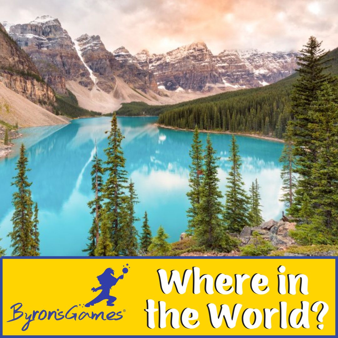
Where in the World Wednesday: Banff National Park, Canada

11/20/2019

1 Comment

 
Picture
Banff National Park (French: Parc national Banff) is Canada's oldest national park and was established in 1885. Located in the Rocky Mountains, 110–180 kilometers (68–112 mi) west of Calgary and 145 kilometers (90 mi) from Calgary International Airport in the province of Alberta, Banff encompasses 6,641 square kilometers (2,564 sq mi) of mountainous terrain, with many glaciers and ice fields, dense coniferous forest, and alpine landscapes. The Icefields Parkway extends from Lake Louise, connecting to Jasper National Park in the north. Provincial forests and Yoho National Park are neighbors to the west, while Kootenay National Park is located to the south and Kananaskis Country to the southeast.

​Banff National Park has a subarctic climate with three ecoregions, including montane, subalpine, and alpine. The forests are dominated by Lodgepole pine at lower elevations and Engelmann spruce in higher ones below the treeline, above which is primarily rocks and ice. Mammal species such as the grizzly bear, cougar, wolverine, elk, bighorn sheep and moose are found, along with hundreds of bird species.
1 Comment

Flag Fact Friday: Albania

11/15/2019

2 Comments

 
Picture
Albanian flag consists of a red leaf where a black double-headed eagle is depicted. The flag was adopted in 1912 when Albania gained independence from the Ottoman Empire. The origin of the flag is associated with a national hero Skanderbeger (formerly George Kastrioti), who lived in the fifteenth century and who was a general of the Turkish army. However, Skanderbeger left the army so that he can return to Albania and erect the flag with a double-headed eagle above the castle of his father in Kruje with words: "I did not bring you freedom. I found it here, among you." After his return to Albania, Skanderbeger managed to unify Albania and defend it against the Turkish attacks.
2 Comments

Where in the World Wednesday: The Great Barrier Reef and Whitehaven Beach, Australia

11/13/2019

1 Comment

 
Picture
Although the Great Barrier Reef—the largest living thing on Earth—can be seen from space, the best vantage point belongs to the avid snorkelers and scuba divers who visit each year. If you must resurface, do it at the Whitsundays—namely Whitehaven Beach, often considered to be one of the world's most beautiful beaches.

Whitehaven Beach is a 7 km stretch along Whitsunday Island, Australia. The island is accessible by boat, seaplane & helicopter from Airlie Beach, as well as Hamilton Island. It lies across from Stockyard Beach, better known as Chalkie's Beach, on Haslewood Island. The beach is known for its crystal white silica sands and turquoise-colored waters.
1 Comment

Flag Fact Friday: Togo

11/8/2019

1 Comment

 
Picture
​The flag of Togo was designed by Aheyi Paul and it has been adopted in 1960. It consists of five horizontal stripes altering between green and orange-yellow color. In the pole part of the flag, a red square that bears the symbol of a white five-pointed star is placed. The colors used are of classic pan-African symbolism, therefore, it stands for solidarity among all the independent African nations. The flag's design is very similar to the Liberian flag. Five lanes allegedly represent the five regions of the country - the coast, the plateau, the central region, the Kara region, and savannas. Another interpretation says that the five bars indicate five fingers, which should symbolize human behavior.
1 Comment

Flag Fact Friday: St. Vincent & The Grenadines

11/1/2019

1 Comment

 
Picture
The flag of the island nation of St. Vincent and the Grenadines which is located in the Caribbean, is composed of three vertical stripes, where the first one is blue, the middle one is wider and yellow and the last one is green. In the middle of the yellow stripe, there are three green diamonds arranged in the shape of the first letter of the name Vincent. The blue represents the sky and the sea, yellow stands for sunshine and green symbolizes lush vegetation of the islands. Green diamonds refer to the national plurality on the islands and also to a large number of islands. Saint Vincent and the Grenadines were once of interest of France and Great Britain, but the British won the fight and they dominated the islands until 1979 when the independence was proclaimed.
1 Comment

Where In the World: Avenue of Baobabs, Madagascar

10/30/2019

2 Comments

 
Picture
The dirt road linking Morondava and Belo Tsiribihina in Madagascar is framed by dozens of rare and ancient baobab trees creating a setting so beautiful and unique that it may become the country’s first official natural monument.

​These giant, dry season-deciduous trees (members of the Mallow family), many of which are more than 800 years old with trunks that are over 150 feet around did not always stand alone. At one time the trees dotting the lane were part of a rich forest of the trees and other plants, but the encroachment of modern civilization and increasing populations in the area led to massive deforestation leaving the remaining baobabs to stand in relative isolation.
​

Baobabs are incredibly useful plants, their trunks are harmlessly tapped for water during the dry season and have even been lived in, the young leaves (when reachable) are eaten as a salad vegetable when little else is available, and the nutritious sour brown pulp (tasting somewhat like tamarind) of the hard-shelled fruits is made into a pleasant summertime beverage all over Africa, and is also an ingredient in a Senegalese peanut and couscous dessert pudding called Ngalakh.
2 Comments
<<Previous
Forward>>

    Categories

    All
    Events
    Family
    Flag Facts
    Golf
    Hero Highlight
    Math
    Music
    Virtual Learning
    Where In The World
    World Geography

Start Here
Meet Byron
Get the Game
Have Fun
Explore More
Store
Get the App!

Copyright © 2025 - Byron's Games